
Resilient Bennington Street and Fredericks Park
The City of Boston and the City of Revere are working together to advance the design of coastal resilience infrastructure across both municipalities.
The City of Boston, in partnership with the City of Revere, has been awarded a Municipal Vulnerability Preparedness (MVP) grant to advance the design of coastal resilience strategies extending along Bennington Street in East Boston and Frederick's Park in Revere. The project will develop schematic designs for an identified priority action area at Bennington Street, Fredericks Park, and Belle Isle Marsh, located at the intersection of East Boston and Revere where flooding occurs today and will increase in the future. The project will use nature-based and hybrid solutions to:
- reduce near- and long-term flood risk to surrounding residences and the MBTA Blue Line
- improve public safety, multi-modal transportation, and recreational open space, and
- enhance the habitat value of Belle Isle Marsh.
-
 Project Information
Project Lead: City of Boston Environment Department and City of Revere Department of Planning & Community Development
Lead Consultant: VHB
Project Type: Coastal resilience infrastructure schematic design
Project Status: Site investigations complete; alternatives analysis underway
Project Budget: $330,500
-
 Project Contacts
Catherine McCandless - Climate Resilience Project Manager, City of Boston: catherine.mccandless2@boston.gov
Elle Baker - Open Space and Environmental Planner, City of Revere: ebaker@revere.org
UPCOMING EVENT!
-
Resilient Bennington Street and Fredericks Park Project Public Meeting
May 2
- When May 02, 2024, 6:00 PM - 7:30 PM
-
Where
Zoom Meeting
Boston and Revere,
United States -
Contact
Catherine McCandless
- Email catherine.mccandless2@boston.gov
- Phone
-
Price
FREE
There are no related events available at this time!
Project Background
Representatives from the City of Boston, the City of Revere, the Town of Winthrop, the Massachusetts Department of Conservation and Recreation, MassDOT, MBTA, The Nature Conservancy, Friends of the Belle Isle Marsh, Mystic River Watershed Association, Woods Hole Group, and HYM Investments have been participating in a multi-year study of the Belle Isle Marsh that began in 2021. Alongside Climate Ready Boston’s work, the study of Belle Isle Marsh identified preliminary strategies to reduce flood risk to the neighboring communities and support ecological restoration opportunities to extend the marsh’s ability to function in the face of climate change. This work builds upon Climate Ready Boston's 2022 Coastal Resilience Solutions for East Boston (Phase II) plan and Revere’s 2019 Municipal Vulnerability Preparedness Summary of Findings Report.
- Belle Isle Marsh Climate Vulnerability Assessment (June 2023)
- Study of Belle Isle Marsh Public Meeting #2: Meeting Recording and Presentation (June 2023)
- Belle Isle Marsh Environmental Inventory, Coastal Modeling, and Restoration Assessment (December 2022)
- Study of Belle Isle Marsh Public Meeting #1: Meeting Recording and Presentation (June 2022)
- City of Boston's Coastal Resilience Solutions for East Boston (Phase II) (August 2022)
- City of Revere’s MVP Summary of Findings Report (June 2019)
COMMUNITY ENGAGEMENT
The Belle Isle Marsh Public Information Session was held on Wednesday, November 15, 2023 from 6:00-7:00 p.m. During this virtual meeting, the Stakeholder Collaborative shared an overview of the Study of Belle Isle Marsh, including key findings about the marsh's vulnerability to climate change and priority areas for coastal adaptation and restoration. After the overview presentation, attendees joined break-out room sessions to learn more about the recently-funded coastal resilience projects at Bennington Street in East Boston/Fredericks Park in Revere, and Morton Street in Winthrop. Thank you to everyone who attended!
A recording of the overview presentation and the break-out room for the Resilient Bennington Street and Fredericks Park project is available, along with the associated presentations:
STUDY OF BELLE ISLE MARSH OVERVIEW:
- Overview Presentation Recording: English | Spanish/Espanol
- Overview Presentation Slides: English | Spanish/Espanol
RESILIENT BENNINGTON STREET AND FREDERICKS PARK BREAK-OUT ROOM:
- Break-Out Room Presentation Recording: English
- Break-Out Room Presentation Slides: English | Spanish/Espanol
Questions & Answers
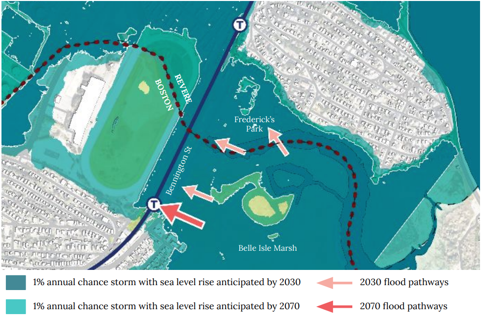
Questions & AnswersThe Belle Isle Marsh is the largest and one of the last remaining salt marshes in Boston. In addition to being a valuable ecological resource for wildlife and climate resilience, it is an important regional recreation space for East Boston, Revere, Winthrop, and other surrounding communities. The Belle Isle Marsh’s long-term health is influenced by human impacts, both historical and present-day, and by the anticipated effects of climate change. The marsh is existentially threatened by rising sea levels, increasingly intense coastal storms, and dense development along its inland borders. Without active intervention, Belle Isle Marsh will become open water in the coming decades, eliminating its coastal flood protection services, carbon storage, and its role as habitat for over 250 bird species (seven of which are listed as threatened or endangered). Addressing the current and future resilience challenges in the Belle Isle Marsh and the surrounding communities is essential to ensure the healthy function of the marsh as a habitat for plants and animals and as a place for community recreation.
Much of Boston and Revere was built on a salt marsh and the low-lying land is vulnerable to flooding along the entire coastline. Three flood pathways originating from within the Belle Isle Marsh present a risk to East Boston and Revere today, and this risk will increase substantially over time. By the 2030s, with 9 inches of sea-level rise, coastal flooding puts Bennington Street, the MBTA Blue Line Suffolk Downs Station and train tracks, Fredericks Park, and residences along Belle Isle Avenue and Montfern Avenue at greater risk of regular flooding even during typical storms. In the longer term, with sea-level rise projected to occur between 2030 and 2070, flood pathways originating from the Belle Isle Marsh contribute to widespread flooding in East Boston and Revere.
The Study of Belle Isle Marsh is a multi-year Municipal Vulnerability Preparedness grant funded study awarded to the Town of Winthrop with facilitation by the Mystic River Watershed Association and Woods Hole Group. Participants in a regional Stakeholder Collaborative have been meeting monthly since 2021 to assess the current and future impacts of flooding and coastal storms on the Belle Isle Marsh and evaluate potential flood risk reduction strategies and marsh restoration efforts. In addition to the City of Boston, City of Revere, and Town of Winthrop, the participants include representatives from the Department of Conservation and Recreation (DCR), Massachusetts Department of Transportation (MassDOT), MBTA, The Nature Conservancy, Friends of the Belle Isle Marsh (FBIM), and HYM Investments (the owner and developers of Suffolk Downs).
The Study of Belle Isle Marsh has identified preliminary nature-based and hybrid solutions to prevent damage to the neighboring communities and MBTA Blue Line, promote public safety, and enhance and extend the habitat value of Belle Isle Marsh based on the Massachusetts Coast Flood Risk Model (MC-FRM) projections for 2070. Since the Study of Belle Isle Marsh began in 2021, the Stakeholders identified 12 project locations along the perimeter of Belle Isle Marsh that should be explored further to address climate vulnerabilities and ecological restoration within the marsh. The Stakeholders collaboratively developed prioritization criteria for these sites and selected this location (as well as a location at Morton Street in Winthrop) as a top priority. The Belle Isle Marsh Climate Vulnerability Assessment (2023) summarizes the study and the recommended next steps.
The City of Boston’s Climate Ready Boston initiative completed the Coastal Resilience Solutions for East Boston (Phase II) plan in 2022 (the “Phase II Plan''), which identified the Bennington Street and Fredericks Park area as a near-term priority for coastal resilience due to the extreme flood risk to the East Boston neighborhood and City of Revere. The Phase II Plan was underway at the same time as the Study of Belle Isle Marsh and the two efforts were developed in coordination with each other.
The project will build upon the Study of Belle Isle Marsh and Climate Ready Boston’s findings through further assessment and exploration of three design alternatives for flood risk reduction on Bennington Street in Boston and Fredericks Park, Belle Isle Avenue, and Montfern Avenue in Revere. All three design alternatives would reduce the risk of coastal flooding that enters Boston and Revere via three flood pathways originating in the Belle Isle Marsh under current conditions by elevating the coastal edge of the project area to address a 1% annual chance storm with 2.5-4.3 feet of sea-level rise projected by 2070.
Through this project, the project team will complete a feasibility assessment, preliminary schematic design of these alternatives, and permitting evaluation to identify a preferred coastal resilience solution to advance to further design that will meet the flood risk reduction objectives while providing a myriad of co-benefits, including stormwater management, urban heat island reduction, and recreational enhancement at Fredericks Park and along Bennington Street.
- Alternative 1 involves elevating a low-lying section of Bennington Street as the core flood risk reduction strategy.
- Alternative 2 involves constructing a vegetated berm within the City of Boston’s right-of-way along Bennington Street, which would require a steeper slope to reach the target design flood elevation.
- Alternative 3 involves constructing a vegetated berm or living levee along Bennington Street in Boston with a gradual slope into the marsh to support marsh migration.
- In Revere, all three design alternatives involve constructing a berm/living levee around Fredericks Park to Montfern Avenue with either a steeper slope and narrower footprint, or a gradual slope into the marsh to support marsh migration, as well as a redesign of Fredericks Park to enhance stormwater management and recreational open space.
The key goals of this project include:
- Conduct a feasibility assessment, preliminary schematic design, and permitting evaluation of three alternatives, and identify a preferred design that will protect East Boston and Revere from the near- and long-term impacts of coastal flooding from sea-level rise and storms;
- Advance the preferred alternative into further design development;
- Redesign Fredericks Park to improve coastal resilience, stormwater management, recreation, and ecological habitat;
- Ensure that all design alternatives support co-benefits along Bennington Street, including green stormwater infrastructure, tree canopy, active transportation (including bicycle and pedestrian travel), etc.; and
- Ensure that all design alternatives support the health and longevity of Belle Isle Marsh.
This project builds off of several years of community engagement by the City of Boston (through Climate Ready Boston's Coastal Resilience Solutions for East Boston (Phase II) planning effort between 2020-2022), the City of Revere (through the MVP-funded Community Resilience Building effort from 2019), and the Study of Belle Isle Marsh (between 2021-2023). These three efforts have involved many meetings, workshops, surveys, working groups, and outreach to involve the East Boston, Revere, and Winthrop communities in developing coastal resilience strategies surrounding Belle Isle Marsh.
Join us at an upcoming event or email Catherine McCandless (catherine.mccandless2@boston.gov) and Elle Baker (ebaker@revere.org) to share feedback, ask questions, or inquire about your participation!
-
Project Information
Project Lead: City of Boston Environment Department and City of Revere Department of Planning & Community Development
Lead Consultant: VHB
Project Type: Coastal resilience infrastructure schematic design
Project Status: Site investigations complete; alternatives analysis underway
Project Budget: $330,500
-
Project Contacts
Catherine McCandless - Climate Resilience Project Manager, City of Boston: catherine.mccandless2@boston.gov
Elle Baker - Open Space and Environmental Planner, City of Revere: ebaker@revere.org
