Vision Zero Data Challenge kickoff meeting
Join us for our Speed Feedback Signs data challenge kickoff presentation on Wednesday, July 26, at CIC Boston.
At the meeting, you'll learn about our new speed feedback signs. You can also ask questions about the data and the hackathon challenge.
We want your best ideas for how you can help make Boston’s streets safer.
About the feedback signs
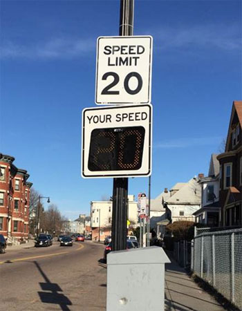
The City of Boston recently procured 30 new radar speed feedback signs.
These signs are solar-powered and digital. We mount them onto street lights, and they:
- display the speed limit and a passing vehicle’s speed, and
- flash when the vehicle surpasses the speed limit.
With these new feedback signs, we’ll have 50 signs out in Boston neighborhoods.
Reducing speed is one of the cornerstones of the Vision Zero Boston plan and a key component to building safer streets. Our experience shows that speed feedback signs reduce average vehicle speeds by roughly 4-5 mph and show even greater speed reductions when placed in school zones. They reduce speeds across the board, not just for motorists who were already traveling at lower speeds.
The challenge
We want participants to analyze a collection of criteria and propose locations where we should install speed feedback signs in the City. More importantly, we want to know the reasons behind your decisions.
The final product shouldn’t just be a list of streets, but a process. We want you to make your case for the method you use.
We expect you to take into account many potential variables, including:
- crash clusters identified using EMS and BPD data
- locations of fatal crashes using BPD data
- data from the online Safety Concerns map
- demographic information, such as density of school aged children, older adults, race and ethnicity, and median income
- land uses, such as schools, parks, elderly housing, and hospitals
- speed studies
- 311 data
- locations of existing speed feedback signs, and
- locations suggested by City staff.


