Army Corps (USACE) Study Partnership
We want your feedback on how we plan to protect our neighborhoods from rising seas and extreme flooding.
Since 2016, the City of Boston has worked with neighborhoods to plan ahead for flooding caused by sea level rise, extreme weather, and climate change. Now, through a partnership with the U.S. Army Corps of Engineers, we are planning to build one of the largest coastal flood protection systems in the country.
On July 24, 2026, the U.S. Army Corps of Engineers released a draft report and opened the public comment period for their Coastal Storm Risk Management Feasibility Study. This important, once-in-a-generation study proposes projects to protect our entire city from coastal flooding. The USACE Draft Integrated Feasibility Report and Programmatic Environmental Assessment is now available to the public.
Share your feedback on the draft report by September 18, 2026 at 5:00 PM EST.
-
Still have questions? Contact:
Climate Resilience
-
 26 Court Street
4th FloorBoston, MA 02201
-
Looking for information on Boston’s work to reduce stormwater flooding? Learn more
THE PROBLEM: EXTREME FLOODING
Flooding in Boston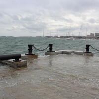
Coastal Flooding
Boston experiences coastal flooding even on sunny days. This flooding will only get worse with extreme weather and climate change.
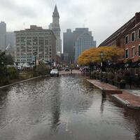
Inland Flooding
Flooding is not just a coastal problem. Some residents who live over a mile away from the ocean could experience severe flooding in their neighborhood in the next 25 years.

Economic Impacts
Every $1 spent on protecting our City could prevent over $4 in losses. If Boston does not act before the end of the century, we could see over $54 billion in damages.
THE SOLUTION: PROTECT OUR COMMUNITY

Protect Lives
Save lives and protect our local economy during severe storms.

Protect Infrastructure
Protect your access to hospitals, rail networks, highways, and economic opportunities.

Improve Quality of Life
Improve your access to green spaces and recreation along Boston harbor.
WHAT IS THE COASTAL STORM RISK MANAGEMENT FEASIBILITY STUDY?
The federal government and the City of Boston agree: coastal flooding could compromise the safety and economic future of our city.
On July 24, 2026, US Army Corps of Engineers (USACE) published a draft report of their Boston Coastal Storm Risk Management Feasibility Study, a once-in-a-generation study presenting possible projects to protect Boston against coastal flooding and sea level rise. By partnering with USACE to create this study, the City of Boston can access billions of dollars in federal funding from Congress to construct infrastructure on the coast that will protect our communities. The draft report is a major milestone before the study is completed by 2028.
In this draft report you will find:
- Locations for projects to protect Boston against coastal flooding.
- Different types of infrastructure projects proposed by the Army Corps of Engineers, such as floodwalls, levees, and floodgates.
- Neighborhood characteristics, such as the environmental resources, cultural institutions, and local history, that will affect what types of projects are constructed.
PROVIDE FEEDBACK BY SEPTEMBER 18th
IN WRITING
Mr. Todd Randall
U.S. Army Corps of Engineers, New England District / ATTN: COB CSRM Project Team / 696 Virginia Road Concord, MA 01742-2751
NEED HELP SUBMITTING FEEDBACK?

USACE Resilience Plans by Community
View the study’s proposed flood protection designs and their locations in neighborhoods across Boston.
Story Map Poster BoardsUpcoming Events
EventsPAST EVENTS
View recordings and slides from past community meetings and project updates for Charlestown, Dorchester, East Boston, the North End, South Boston, and Wharf District.

COASTAL RESILIENCE WORK IN BOSTON
Boston does not shy away from bold action. We are doing the hard work to protect our communities from future catastrophes before they strike.
Between 1991 and 2026, Boston experienced 24 severe weather events that triggered federal or state disaster declarations, with 14 events experiencing flooding from coastal storm surge, effects of sea level risk, increased rainfall, or a combination of all three.
This work to protect our city would not be possible without the collaboration and perspective of our communities. Over the last decade, the City of Boston has engaged thousands of residents and stakeholders across Boston's coastal neighborhoods, making this one of the most extensive community-driven resilience planning processes in the country.
In 2016, the City of Boston wrote its Climate Ready Boston plan, which outlined Boston’s adaptation efforts to protect the city from three major climate hazards: extreme heat, stormwater flooding, and coastal and river flooding. It also identified climate resilience initiatives to enable Boston to address these risks and continue to thrive in the face of climate change.
From 2017-2022, the City of Boston created local Coastal Resilience Solution Plans to identify the location of flood risks and opportunities for flood prevention infrastructure across each neighborhood. This work required engaging stakeholders to identify key priorities, opportunities, and constraints to inform coastal resilience strategies. As a result, the City developed coastal resilience solutions and an implementation roadmap that outlines the timing by which strategies need to be constructed and next steps for advancing each proposed project in each neighborhood.
Frequently Asked Questions
FAQsThe study process includes the following phases:
Scope and creation of alternative solutions
- Develop different flood protection and management measures
Solution Evaluation and Analysis
- Assess the quality of proposed alternative solutions and if they reach the partnership's goals
Feasibility Analysis
- Measure of the likelihood of success of the preferred solution
Washington-level review
- The preferred solution is sent to the federal government to determine whether it will receive funding

CSRM studies are typically completed in three years. However, timelines for very large or complex studies can extend if necessary. After an initial review of the project scope, Army Corps and City of Boston teams agreed that due to the study size, location, and complexity of the project, the study needed six years instead of three. The current schedule below was approved by the Office of the Assistant Secretary of the Army for Civil Works in 2023, and is up to date as of September 2025.
- Alternative Milestone Meeting, Completed February 2023
- Tentatively Selected Plan Milestone, anticipated Winter 2026
- Release of the Draft Feasibility Report, anticipated Spring 2026
- Submittal of Final Feasibility Report, anticipated Fall 2027
- Signed Chief's Report (Final Milestone), anticipated Spring 2028
The study area is within the administrative borders of the City of Boston. The study builds on the City’s previous efforts through Climate Ready Boston. It includes the five coastal neighborhoods along Boston Harbor: Charlestown, East Boston, Downtown and North End, South Boston, and Dorchester. The Study will consider long-term flood risk in combination with sea level rise.
The Study will be conducted alongside other USACE and State studies, including the Boston Metropolitan Area Coastal Study, New Charles River Dam Planning Assistance to States Study, and Muddy River Flood Risk Management and Environmental Restoration project. Part of the study strategy is to align the Study’s recommendations with state and regional planning efforts for consistency and comprehensiveness.
The study will build on the Climate Ready Boston initiative and recommend measures that are eligible for direct federal investment. The study will incorporate near-term Climate Ready Boston projects that are in the process of design and construction and allow for close consideration and coordination on the City’s medium to long term plans. The study is uniquely positioned to consider the entirety of existing city, federal, state, and local plans and projects.
The City of Boston CSRM Study is taking place in parallel with the Boston Metropolitan Area Coastal Resilience Study. That study is being conducted by USACE and the State of Massachusetts Executive Office of Energy and Environmental Affairs. It will assess long-term risk and resilience at a watershed level. Both studies are carried out in close coordination. Recommendations of the City of Boston Study will be aligned with state and regional plans.
The USACE Planning Assistance to States Study of the New Charles River Dam is a state-level study looking at future impacts of climate change and sea level change on dam operations. This technical study will assist the State in identifying when and how the dam should be adapted, physically or operationally. The results of the Charles River Dam study will be built into the City of Boston CSRM Study.
The City’s near-term projects will continue as planned and will be built into USACE coastal and engineering models describing existing and future conditions and flood impacts. The City will coordinate and remain in alignment with USACE on medium- and long-term projects. Overall, we will balance the City’s ongoing near-term coastal resilience efforts with proposed longer term solutions identified through the CSRM study.
USACE recognizes that the City has been through an extensive planning and community engagement process and has received significant community feedback. All past work will be included in this study. We will begin with the conceptual designs developed through Climate Ready Boston and will complete a required formulation process and feasibility analysis to make final recommendations and unlock access to federal resources for design and construction.
We encourage participation of communities as partners throughout the duration of the study, including during the:
- needs assessment
- feasibility analysis
- development of recommendations, and
- ultimately implementation.
We will create many opportunities and means to engage and provide feedback, including office hours, feedback forms, newsletters, coffee chats with City officials, and more. Please follow this website for updates.
We invite all residents and community members to participate in the study. We will involve a wide range of community stakeholders, including:
- residents of coastal neighborhoods
- property owners and property owner associations
- neighborhood councils
- community-based and civic organizations
- local businesses
- youth and educational organizations, churches, and
- others.
The Study team will ensure continuity and build off of the CRB community engagement efforts.
The study will consider both:
- structural (e.g., seawalls, floodwalls, revetments, surge barriers, elevated harborwalks, nature-based solutions), and
- non-structural measures (e.g., permitting requirements, zoning changes, building-based adaptation, evacuation routes).
Yes, nature based solutions are an important component of coastal resilience and we will consider these strategies wherever possible in the study. We will examine harbor conditions, considering Boston’s tide range and varied exposures to wave energy, as well as factors such as coastal adaptability to evaluate to what extent nature-based solutions could be appropriate in specific locations. We will also examine opportunities to use nature-based solutions in combination with other measures.
ThesStudy is cost-shared 50/50 between the City and the federal government. The City has committed to this project in its capital budget. In the longer term, if the study unlocks congressional authorization, a large fraction of federal cost-share will support the design and construction of the recommended projects.
USACE routinely works closely with other federal agencies, such as:
- the Federal Emergency Management Agency (FEMA)
- the U.S. Coast Guard
- the National Parks Service
- the U.S. Fish and Wildlife Service
- the National Oceanic and Atmospheric Administration’s National Marine Fisheries Service, and
- the U.S. Environmental Protection Agency.
USACE has invited many entities to participate in the study process. While USACE does not develop plans to meet FEMA requirements, they collaborate with FEMA and to identify risk in the floodplains.
State agencies who own coastal land are closely involved as stakeholders and resource agencies for this study. This includes:
- the Massachusetts Port Authority (Massport)
- the Massachusetts Bay Transportation Authority (MBTA), and
- the Department of Conservation and Recreation (DCR).
This study will consider these Agencies’ individual resilience and asset protection plans.
While this study is only one element of coastal resilience work, it may serve as an opportunity to advance other types of resilience. We will evaluate coastal storm risk, but to fully understand the risk and impact, it is important to understand the impacts of other stressors. This study will not recommend housing projects, or changes to transit, nor will USACE seek to influence how the city invests in economic development. However, by understanding these stressors, we can identify a comprehensive plan to manage coastal storm risk without exacerbating other stressors. The opportunity comes in raising awareness of the impacts to other federal, state, and local agencies, which can then lead to additional resilience work. Concerns identified through this study will be integrated into broader Climate Ready Boston and general City of Boston activities and efforts outside of this study.
Based on the selected plan, USACE will lead the design, engineering, and construction of the recommended flood protection measures in partnership with the City. The development and construction of the project will be cost-shared between the City of Boston and USACE. Meanwhile, the City of Boston will keep working to advance near-term coastal resilience projects. The City of Boston as the non-federal partner will be responsible for operations and maintenance of the project. However, USACE will routinely inspect the project for maintenance and upkeep. If a storm event causes damage to the project, it is rehabilitated at full federal cost. The partnership will continue after the project is constructed.
Based on the selected plan, USACE will lead the design, engineering, and construction of the recommended flood protection measures in partnership with the City. The development and construction of the project will be cost-shared between the City of Boston and USACE. Meanwhile, the City of Boston will keep working to advance near-term coastal resilience projects. The City of Boston as the non-federal partner will be responsible for operations and maintenance of the project. However, USACE will routinely inspect the project for maintenance and upkeep. If a storm event causes damage to the project, it is rehabilitated at full federal cost. The partnership will continue after the project is constructed.
-
Get in touch with us directly. Email Kate Roosa at kathryn.roosa@boston.gov.
- Book a virtual office hours session.
NEWS

-
Still have questions? Contact:
Climate Resilience
-
26 Court Street
4th FloorBoston, MA 02201
-
Looking for information on Boston’s work to reduce stormwater flooding? Learn more
