
State Street
State Street is one of the oldest streets in Boston. With this project, we will rebuild it for everyone who uses it — from people who live nearby to visitors from across the world.
We're working on a complete reconstruction of State Street between Surface Road to Congress Street. We plan to rebuild this historic street with:
- sidewalks that are accessible to the thousands of daily pedestrians
- upgraded street lighting
- safe bicycle accommodations, and
- vital commercial loading for small businesses.
-
Have questions? Contact:
Public Works - Engineering Division -
Get Updates
Sign up for email updates about this project.
Upcoming meetings
There are no related events available at this time!
Why rebuild State Street?
State Street is part of Boston's historic fabric. It has changed a lot over the years, but is in need of improvements to keep it functional in the 21st century.
Today's State Street is used by tourists, nearby residents, small businesses, commuters, and people who are simply passing through to another destination. But, it hasn't been updated in a while.
- The condition of the roadway is poor and many sections of the sidewalk are inaccessible.
- Pedestrian space is inadequate. People are often walking in the street or crossing away from crosswalks.
- The curbside uses have not been comprehensively studied, creating an unorganized street.
- The rate of traffic crashes resulting in injury to people on foot or on bicycle is among the highest in the City.

Pilot Design
We have made changes to the final design based on the feedback we received through our public engagement process.
We shared the final design for State Street at a public meeting on March 13, 2022.
We are excited to move to the next step with the project, but we need input on how to best use the curb on State Street. We look forward to working with you to get the details right.
As part of Boston's Healthy Streets initiative, we used quick-build materials to test a redesign of State Street.
- We used thermoplastic paint and flexible delineator posts to create new pedestrian spaces, separated bike lanes, more visible crosswalks, and changes to curbside access.
- We have been collecting data regularly, including the volume of people using the street by foot, by bike, and by vehicle. We have also observed traffic conditions during busy times.
- This design does not reflect all the benefits of a full reconstruction. It does not address sidewalk condition and accessibility for persons with disabilities. It also does not update the lighting or improve the roadway condition.
During this temporary redesign, we found that:
- The number of injury-causing crashes was 57% lower for all modes (2020-2021), as compared to the two years of crashes prior (2018-2019).
- Despite COVID-related shutdowns, 15% more people were biking on State Street in June 2021 as compared to July 2019.
- Of the 212 surveys completed about the pilot design, 96% of State Street travelers were satisfied or very satisfied with the space allocated to pedestrian and bicycle use.
Improving Safety
With this project, we must improve safety for people who are bicycling and walking.
State Street has been identified as a high-crash corridor by the City of Boston. The Massachusetts Department of Transportation finds that segments of State Street are among the highest crash locations for pedestrians and bicyclists in the Commonwealth.
In the City of Boston, we use a combination of data from EMS and the Boston Police Department (BPD) to understand where injury- and fatality-causing crashes happen. These are authoritative data sources. The City's EMS shares data on crashes requiring an EMS response. Because we do not track severity of injury by other data sources, the information from EMS helps us identify places where people are hurt in a crash. We use BPD information to confirm fatalities that result from a traffic crash.
We used methodology recommended in the Federal Highway Administration's Guidebook on Identification of High Pedestrian Crash Locations to:
- analyze EMS data, and
- identify high-crash segments for all modes of travel.
We scored each 1/2-mile segment of roadway based on the number of crashes resulting in an injury or death. Fatal crashes were weighted three times more than non-fatal injury crashes. We then overlap each segment in increments of 1/10-mile to identify those segments with the highest score. We last did this analysis using three years of data, from 2015 through 2017.

State Street is in the top 3% of streets, citywide, for bicycle crashes.
Vital pedestrian route
State Street is among Downtown's most important connections for people on foot.
Taking in iconic views or stopping at lunchtime favorites — thousands of people walk along or across State Street every day. During pre-pandemic summer months, people on foot outnumbered vehicles 3 to 1.
Tourists from around the world visit State Street, learning about its important place in Boston's history and taking in views of the Old State House. They can walk out to Long Wharf to watch ships on the Harbor, or to take a ferry. They may also be coming from a tour bus stop, which we've worked to place along the Rose Kennedy Greenway between Atlantic Avenue and Surface Road.
State Street is important for residents too. It offers access to MBTA stations and a link to the City north or south of Government Center. Even as office workers report remotely, many are still visiting State Street's restaurants at lunch or for an after-work break.


Keeping Traffic Moving
Before and during our pilot project on State Street, we have tracked the number of people using State Street.
Our initial ideas for State Street included closing portions of it to traffic. Although this was a popular idea, we heard from nearby residents and businesses that diverting traffic elsewhere would be problematic. There are few direct alternatives that connect Atlantic Avenue/Surface Road to Cambridge Street. While we explored some network changes, ultimately we found few routes that would meet the needs of our residents, businesses, and visitors.
We collected traffic volumes before and during the pilot. We also calculated travel time for drivers during the busiest parts of the day:
- a.m. peak hour
- midday peak hour, and
- p.m. peak hour.


Commonly asked questions
QuestionsThe elimination of vehicle traffic along State Street was considered. This concept would be similar to how Downtown Crossing currently functions, where the entire public right-of-way is available for:
- pedestrians
- cyclists, and
- delivery vehicles (at designated times of the day).
There are two primary obstacles to removing vehicle traffic from State Street:
- It is difficult to reroute and redistribute State Street traffic within the existing street network. There are few direct east-west alternative routes that connect Atlantic Avenue / Surface Road to Cambridge / Tremont Streets. Significant changes to the existing network would be required. These include possible changes to one-way streets in the downtown, or allowing left turn movements at locations that are currently prohibited, or both. We explored some network changes. But, ultimately we found few routes that would meet the needs of our residents, businesses, and visitors. We can continue to evaluate alternative network options for vehicle traffic. We would analyze traffic routing and volumes on a slightly larger scale and share ideas with the public for their feedback. We anticipate some of this study will happen through our efforts to provide bus priority travel on Congress Street, serving North Station and the South Boston Waterfront.
- There are two parking garages adjacent to the project at 60 and 75 State Street. For patrons to access these garages, a portion, if not all of State Street, would need to remain open to vehicle traffic.
We plan to design State Street to support current vehicular needs. But, we'll also keep in the mind the potential for temporary pedestrianization for events, or to support future uses of the street.
We have heard interest in providing at least two travel lanes on State Street for general traffic. However, traffic modeling and observations during the pilot do not support this need.
The pilot design provides a configuration that balances and provides space for all users. These include pedestrians, bicyclists and motor vehicles. We have retained the three travel lanes approaching Congress Street. We're also creating:
- a separated bike lane
- a few new pedestrian areas, and
- delineated space for parking and loading.
We have one travel lane from Atlantic Avenue/Surface Road. This is because only one lane is feeding into State Street at any given time. We keep this one-lane through the narrowest segment of State Street. But, we then provide more travel lanes to accommodate queuing vehicles during the busiest times of day.

On a regular day, it can take about three minutes to drive from Surface Road and leave through the Congress Street intersection. This time is governed by the signal timing and phasing at the intersection of Congress Street. Here, many people on foot, on bike or bus, or in a car are moving in many directions. All of these movements are competing for limited time within a traffic signal cycle. We work to optimize that intersection as best as possible, sharing delay among all the movements. We recognize that during unusual times, like extended disruption on the Blue Line, State Street was congested for more times of day. But providing a second lane is unlikely to have measurably lessened congestion or significantly improved travel times for people in vehicles.
In addition, our citywide goals include:
- increasing the number of trips taken by bike, and
- preventing the types of crashes that result in serious injury or fatality.
If we provide two travel lanes the length of State Street, we create conditions that could be dangerous to people crossing the street. We also would not have room for an important bike connection.
On streets with more than one vehicular travel lane in the same direction, people crossing the street face a "double threat." That is, one driver may stop for them as they cross the road. But, the driver in the second lane cannot see the pedestrian and may not slow down or stop in time. This can also happen when drivers have double-parked, blocking the view of passing drivers. This type of crash is illustrated below.

We have modeled traffic on State Street in a single travel lane using pre-pandemic (2018) traffic volumes. The amount of traffic that can move along State Street, in any scenario, is governed by the the signal timing and phasing at the intersection of Congress Street. Here, many people on foot, on bike or bus, or in a car are moving in many directions. All of these movements are competing for limited time within a traffic signal cycle.
We work to optimize that intersection as best as possible, sharing delay among all the movements. In the first year or so of the pandemic, we kept this traffic signal on "off peak" timing. That means the total time for every movement by drivers, buses, or people on foot, was less than what was provided pre-pandemic. That reduced delays for everyone while volumes were lower. In more recent months, we have changed our signal timing to accommodate larger volumes of vehicle traffic.
This project seeks to continue to maximize vehicle throughput at the Congress Street signal by retaining the number of approach lanes. Now and pre-pandemic, we provide three general purpose travel lanes for drivers approaching Congress Street. We monitor and adjust our traffic signals on a regular basis. We sometimes make changes each day to accommodate that day's unique patterns and keep people moving.
We have monitored traffic volumes and average travel times during the busiest times of day for drivers. We find that it can take up to 3 minutes to drive from Surface Road through the signal at Congress Street. We recognize and understand that this trip can be longer during unusually busy times.
It is reasonable to expect vehicle congestion during the peak commuting hours in any dense urban downtown like Boston. This would not change whether there is one or two vehicle travel lanes along State Street. Vehicle congestion occurred along State Street prior to the pandemic. It's likely to return post-pandemic.
Another factor that greatly impacts vehicle capacity on State Street is the high number of uncontrolled pedestrian crossings. These are somewhat unique but critically important to the vibrancy of State Street. Particularly during the lunch hour, the high number of pedestrian crossing movements along State Street introduces vehicle delay. State Street is a busy urban street within the Financial District and a prime tourist destination. The high number of pedestrian crossings is just one of the factors that contribute to the "friction" that is evident along the roadway. Loading, bicycle traffic, emergency vehicles, trucks, double parking, food delivery, ride-hail vehicles such as Uber and Lyft, tour buses: these are all elements that contribute to the "friction" for traffic but the vibrancy of State Street.
As we observed before the pilot project, State Street would be used as two vehicle travel lanes during peak traffic periods. The additional travel lane essentially provided space for vehicles to queue during the peak hours while remaining under-utilized the rest of the day.
That said, if vehicle demand remains unchanged into the future, additional congestion is likely on State Street. Unlike many other communities, there are more sustainable and equitable alternatives to driving. The City is working to encourage, expand, and embrace these options. We are investing in:
- making our bus service more reliable,
- providing affordable access to transit and bicycling, and
- increasing accessibility of our public streets and spaces.
We are also using our limited street space to provide more trees and permeable spaces. We want to improve our resiliency in hot weather and improve air quality.
Enabling more trips by bike is essential to reaching our climate and public health goals. We need to make sure our streets are safe for the thousands of people who bike today — and for the many more who will choose to ride tomorrow.
While each block of safe, comfortable bike lane is important, it's more important that they connect to each other. A connected network is worth more than the sum of its parts. And, our growing bike network must include the types of bike facilities that make the most people feel comfortable on busy downtown streets: separated bike lanes.
State Street is the ideal route for westbound bike traffic because we can provide a direct, legible connection to existing separated bike lanes on Tremont Street and Cambridge Street. These lanes connect to key destinations in Boston and nearby cities. And, we're extending the State Street project to include a separated bike lane from Congress Street to Tremont Street/Cambridge Street, closing a gap in the downtown bike network.
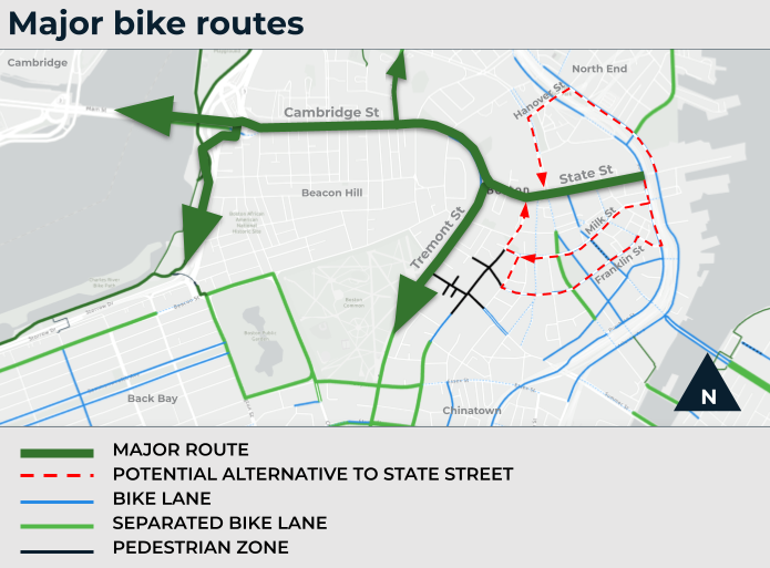
Some have suggested putting the bike lane on Milk Street instead of State Street. While we appreciate the input, we've evaluated the idea and decided against it. Through a separate project, we are designing an eastbound separated bike lane on Milk Street. However, Milk Street is not suitable to provide a direct, legible westbound connection in line with our citywide mobility goals. Here's why:
- Milk Street is an indirect and longer route for westbound bicyclists, especially those heading to Tremont Street and points south. Franklin Street and Hanover Street pose similar challenges.
- We would need space for a continuous two-way separated bike lane to accommodate both eastbound and westbound bike traffic. On narrow downtown streets like Milk Street, the extra space needed for two-way bike traffic can require bigger impacts to parking and other curbside uses.
- Two-way separated bike lanes need careful planning at signalized intersections to avoid conflicts with pedestrians and turning vehicles, often resulting in more delay for all users. This consideration is less critical for one-way separated bike lanes like those planned for State Street.
In conclusion, State Street offers the most direct, legible, and feasible option for a westbound separated bike lane, aligning with our citywide mobility goals.
Previous project updates
Previous updatesOn November 18, 2020, we hosted an Advisory Group meeting.
In October 2020, we shared a virtual update on the State Street project. This video was shared on our project website and through our project lists. In this video, we covered:
- Context for the project, including network needs and crash history
- Design elements that will be part of the project, including wider sidewalks and safer crosswalks; a separated bike lane; flush street design; and pedestrian head-start signals.
- Option for redesigning each segment of State Street
- Potential changes to curb regulation on State Street and other nearby streets
- An update on the "quick build" temporary design using pavement markings, flexible delineator posts, and signage.
- Data collected in August 2020, including volumes by mode of travel

On October 7, 2020, we hosted an Advisory Group meeting.
On September 2, 2022, we hosted an Advisory Group meeting.
In July 2020, we shared a virtual update on the State Street project. This video was shared on our project website and through our project lists. In this video, we covered:
- City-wide plans, policies, and design guidelines that will inform the project
- Conditions on State Street, including sidewalk quality; curb regulations; variation in the width of State Street; the number of people who use the street by foot, by bicycle, and by vehicle
- A summary of public input received from October 2019 through June 2020
- The City's Healthy Streets program, including temporary traffic barrels and cones on State Street

On Wednesday, May 20, we hosted an Advisory Group meeting.
On Wednesday, April 1, 2020, we hosted an Advisory Group meeting.
On Wednesday, March 4, 2020, we hosted an Advisory Group meeting.
On Thursday, February 6, 2020, we hosted an Advisory Group meeting.
In October 2019, we launched our public engagement process to help us redesign State Street. We set up tables and easels on State Street at Merchants Row. From 10:30 a.m. until 6 p.m., we chatted with people on the street about their ideas for a better State Street. We also launched an online survey to gather feedback.
The project was covered in the Boston Globe in January 2020.

We shared our preferred design direction for State Street at a public meeting on June 15, 2022.
We shared the final design for State Street at a public meeting on March 13, 2022.
Download the presentation
In June 2022, the City provided a detailed response to a proposal by the Wharf District Council for an alternative design for State Street.
Project limits

-
Have questions? Contact:
Public Works - Engineering Division -
Get Updates
Sign up for email updates about this project.
