Summer 2026 Traffic Advisory
Parking restrictions and street closures will be in effect in the City of Boston during summer events this year.
The City of Boston will host a historic summer of global events across Boston, including Boston 250, the FIFA World Cup™, and Sail Boston. From these iconic large-scale celebrations to community-based programming like watch parties and small business activations, Boston is creating dynamic, welcoming experiences in every corner of the city.
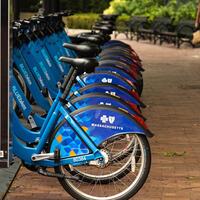
People coming into the City for these events are urged to take public transportation. The MBTA’s guide to public transportation during the World Cup can be found here. Information on Bluebikes, the City’s public bike share system, can be found on the Bluebikes website. Walking is also a great way to move around Boston.
PLEASE NOTE:
Changes to the restrictions on this page may be made by the City of Boston’s Police and Transportation Departments. It is important to read all posted signs and variable message boards carefully.
Events such as parades, road races, and street fairs may require road closures to accommodate the activities.
- Last updated:
-

Stay Connected
Sign up to receive traffic alerts and notifications.
Roadway Closures and Parking Restrictions
Starting on Saturday, July 11, 2026, ships from around the world will gather in Boston Harbor for the Sail Boston events which will conclude on Thursday, July 16.
This will include a "Parade of Sail" on Saturday, July 11, which will require road closures and parking restrictions throughout multiple neighborhoods on that date.
Many streets involved in the Parade of Sail event will be closed for the parade procession itself. While all streets involved in the event will be difficult to traverse for the duration of the event, the specific streets that will be closed can be found on the Sail Boston website here.
Parking restrictions will be in effect throughout Saturday on the following streets in the following neighborhoods:

CHARLESTOWN
- Baxter Road - Both sides, First Avenue heading southerly for its entirety
- Chelsea Street - South side (Navy Yard side), from Constitution Road to Fifth Street.
- Constitution Road - Both sides, from Warren Street to Chelsea Street.
- Eighth Street - Both sides, from First Avenue heading southerly for its entirety.
- Fifth Street - Both sides, from Chelsea Street to First Avenue.
- First Avenue - Both sides, from Fifth Street to Sixteenth Street.
- Flagship Avenue - Both sides, from Eighth Street heading westerly for its entirety.
- Ninth Street - Both sides, from Third Avenue heading southerly for its entirety
- Seventh Street - Both sides, from First Avenue to Third Avenue.
- Sixteenth Street - Both sides, from Chelsea Street First Avenue.
- Sixth Street - Both sides, from First Avenue to Third Avenue.
- Terry Ring - Both sides, from First Avenue heading southerly for its entirety.
- Thirteenth Street - Both sides, from Chelsea Street heading southerly for its entirety
- Warren Street - Both sides, from Chelsea Street to Constitution Road
LIMITED PARKING GARAGE AVAILABILITY
The Charlestown MGH Shipyard Garage will accommodate up to 100 Navy Yard residents only with free parking from Friday, July 10 at 7 a.m. through Monday, July 13 at 9 a.m. Cars must be removed by Monday morning at 9 a.m. or be subject to regular rates.
The garage is located at 199 13th Street.
Please note: This limited free parking only applies to Navy Yard residents during the specified time period. Proof of Navy Yard residency must be provided with driver’s license or vehicle registration. Drivers must stop by the garage office to receive the free parking and may contact the garage with questions by calling 617-726-0553.

EAST BOSTON
- Marginal Street - Both sides, from Orleans Street to approximately 470 east of Jefferies Street (to where the street ends), which includes either side of the marina.
- Sumner Street - South side (water side), from New Street to Liverpool Street.


NORTH END / WATERFRONT
- Battery Street - Both sides, from Commercial Street heading easterly to end of city jurisdiction.
- Long Wharf - Both sides, from Old Atlantic Avenue heading easterly to end of city jurisdiction/BPDA jurisdiction.
- Atlantic Avenue, North End - East side (water side), from Commercial Wharf to Lewis Wharf/Commercial Street
- Atlantic Avenue, Waterfront - East side (opposite the Rose Kennedy Greenway), from Seaport Boulevard to the curb cut in between Boston Harbor Hotel and 400 Atlantic Avenue East side (opposite the Rose Kennedy Greenway), from after the curb cut after 10 and 20 Rowes Wharf to Milk Street
- Chelsea Street, Charlestown - South side (water side), from North Washington Street to Constitution Road
- Commercial Street, North End - East side (water side), from Atlantic Avenue/Lewis Wharf to Battery Street
- Farragut Road, South Boston - East side (park side), from East Fourth Street to East Second Street excluding the MBTA bus stop
- Seaport Boulevard, Seaport District - North side (odd side), from Pier 4 Boulevard to Sleeper Street
- Sleeper Street, Seaport District - East side (odd side), from #51 Sleeper Street to Seaport Boulevard
- Sumner Street, East Boston - North side (house side), from Liverpool Street to New Street


SEAPORT
- Black Falcon Avenue - Both sides, for its entire length, from Drydock Avenue to Terminal Street
- Codfish Way - Both sides, for its entire length, from FID Kennedy Avenue to Shoreline Road
- Courthouse Way - Both sides, Northern Avenue to Liberty Drive
- Dolphin Way - Both sides, for its entire length, from FID Kennedy Avenue to the South Jetty
- Dry Dock Avenue - Both sides, for its entire length, from Summer Street to Black Falcon Avenue
- FID Kennedy Avenue - Both sides, for its entire length, from Dolphin Way to approximately 660’ west of Seafood Way (by the rear of the Leader Bank Pavilion)
- Harbor Street - Both sides, for its entire length, from Dry Dock Avenue to Northern Avenue
- Northern Avenue - Both sides, from Northern Avenue Bridge (near Sleeper Street) to Pier 4 Boulevard. Both sides, from MassPort Haul Road to Tide Street
- Seafood Way - Both sides, for its entire length, from Northern Avenue to Shoreline Road
- Seaport Boulevard - South side (odd side), from Atlantic Avenue to B Street, North side (water side) from Pier 4 Boulevard to B Street
- Shellfish Way - Both sides, for its entire length, from FID Kennedy Avenue to Shoreline Road
- Shoreline Road - Both sides, for its entire length, from Seafood Way to Swordfish Way
- Swordfish Way - Both sides, for its entire length, from FID Kennedy Avenue to Shoreline Road
- Tide Street - Both sides, for its entire length, from Dry Dock Avenue to FID Kennedy Avenue
SEAPORT DISTRICT - FAN PIER / PIER 4 PRIVATE OWNERSHIP
- Bond Drive - Both sides, from Fan Pier Boulevard to Marina Park Drive
- Fan Pier Boulevard - Both sides, from Seaport Boulevard to Waterside Avenue
- Harbor Shore Drive - Both sides, from Northern Avenue for its entirety
- Liberty Drive - Both sides, from Courthouse Way to Marina Park Drive
- Marina Park Drive - Both sides, from Northern Avenue to Waterside Avenue
- Pier 4 Boulevard - Both sides, from Northern Avenue heading northeasterly for its entirety
- Waterside Avenue - Both sides, from Fan Pier Boulevard to Marina Park Drive

SOUTH BOSTON
- East First Street - North side (park side), from Farragut Road to O Street.
- Farragut Road - East side (park side), from Day Boulevard to East Fourth Street, excluding MBTA Bus Stop, East side (park side) from East Second Street to East First Street
LIMITED PARKING GARAGE AVAILABILITY
Limited discount parking will be available for South Boston resident parking permit holders from Friday, July 10 at 5 p.m. through Sunday, July 12 at 12 p.m. at the Channel Center Garage at 116 West First Street.
South Boston resident permit holders will be charged $10/day during this time; all other parkers will be charged the regular rate. Each day begins at 3:30 a.m.
Please note: This rate only applies during the specified time period, and residents must stop by the garage office before driving to the exit to receive the discount. Please contact the garage with questions by calling 617-269-1077.
Boston’s Fourth of July Parade: Saturday, July 4
The parade begins at Copley Square, marching east on Boylston Street, turning left on Tremont Street, and then right on Court Street to State Street (reading from the old State House balcony), then a smaller group will follow Congress Street to Faneuil Hall. The parade will kick off at 9 a.m.
Parking restrictions will be in place, and road closures should be expected, on the following streets:
- Boylston Street - Both sides, from Exeter Street to Tremont Street
- Tremont Street - Both sides, from Boylston Street to Court Street
- Court Street - Both sides, from Tremont Street to State Street/Washington Street
- State Street - Both sides, from Congress Street to Court Street/Washington Street
- Devonshire Street - Both sides, from State Street to Quaker Lane
July 4th Celebration on the esplanade: Monday, June 29 – Sunday, July 5
Parking restrictions will be in place to accommodate the July 4th celebration on the Esplanade. They will be in place from Monday, June 29 to Sunday, July 5.
Road closures should be anticipated. The Boston Police Department closes Beacon Street from Arlington Street to Hereford Street, beginning around 7:00 p.m. Charles Street also closes for the dispersal, and the closure is from Charles Circle to Boylston Street.
Parking restrictions will be in effect from Monday through Sunday on the following streets:
- Beacon Street - North side (even side), from David G. Mugar Way to the dual head meter in front of 120 Beacon Street (DC138, DC139)
- Stuart Street - North side (odd side, Transportation Building side), the last 4 metered parking spaces next to the MBTA Bus Stop, CC218, CC217, CC216, CC215 at the Charles Street South end
Parking restrictions will be in effect from Friday through Sunday on the following streets:
- Stuart Street - North side (odd side, Transportation Building side), from Tremont Street to Charles Street South, unless otherwise posted (see 4 metered spaces above)
Parking restrictions will be in effect throughout Friday and Saturday on the following streets:
- Arlington Street - Both sides, from Beacon Street to Commonwealth Avenue
- Berkeley Street - Both sides, from Marlborough Street to Back Street
- Clarendon Street - Both sides, from Marlborough Street to Back Street
- Dartmouth Street - Both sides, from Marlborough Street to Back Street
- Exeter Street - Both sides, from Marlborough Street to Back Street
- Beacon Street - Both sides, from Charles Street to Dartmouth Street (unless already posted)
- Back Street - Both sides, from Dartmouth Street to David G Mugar Way
- Chestnut Street - Both sides, from David G Mugar Way to Brimmer Street
- Mount Vernon Street - Both sides, from David G Mugar Way to Brimmer Street
- Pinckney Street - Both sides, from David G Mugar Way to Brimmer Street
- Revere Street - Both sides, from David G Mugar Way to Charles Street
Parking restrictions will be in effect throughout Saturday on the following streets:
- Arlington Street - Both sides, from Commonwealth Avenue to St. James Avenue
- Berkeley Street - Both sides, from Marlborough Street to Boylston Street
- Clarendon Street - Both sides, from Commonwealth Avenue to Marlborough Street
- Dartmouth Street - Both sides, from Commonwealth Avenue to Marlborough Street
- Exeter Street - Both sides, from Commonwealth Avenue to Marlborough Street
- Fairfield Street - Both sides, from Commonwealth Avenue to Back Street
- Gloucester Street - Both sides, from Commonwealth Avenue to Back Street
- Hereford Street - Both sides, from Commonwealth Avenue to Back Street
- Massachusetts Avenue - Both sides, from Commonwealth Avenue to Back Street
- Beacon Street - Both sides, from Dartmouth Street to Charlesgate East
- Boylston Street - Both sides, from Berkeley Street to Arlington Street
World Cup matches are scheduled for June 13, June 16, June 19, June 23, June 26, June 29, and July 9. More details are available on the organizers’ website.
Friday, June 26 - Match 61 of the 2026 FIFA World Cup game between Norway and France
On World Cup match days, the following street closures and parking restrictions will be in place:
- Both lanes of Summer Street between Purchase Street at Dewey Square and Dorchester Avenue will be closed to traffic for South Station queuing operations.
- Summer Street will be closed between Purchase Street at Dewey Square and Dorchester Avenue starting at 4:00 a.m. The street is scheduled to remain closed until 2:00 p.m.
- The I-93 South 16A ramp exit will be closed starting at 3:30 a.m. The exit ramp is scheduled to remain closed until 3:00 p.m.
- Additional closures of Summer Street will take place from Surface Road to Atlantic Avenue on the outbound travel lanes on all match days.
- Essex Street between South Street and Atlantic Avenue will be closed except for MBTA buses and traffic entering or leaving the 2 Financial Center garages.
- Parking regulations will be adjusted on Atlantic Avenue between Kneeland Street and Summer Street.
Bluebikes will have valet bike parking service available at the Government Center station on all seven World Cup match days. When riding to Fan Festival on City Hall Plaza on those dates, a Bluebikes representative will ensure there is an open dock for you at your destination so you can head straight to your destination — no worrying about full docks or searching for an open spot.
FIFA Fan Festival at City Hall Plaza – Friday, June 12 to Saturday, June 27, 2026
On June 12-27, 2026, the FIFA Fan Festival will take place on City Hall Plaza as fans, residents, and visitors celebrate the World Cup. During Fan Festival, parking restrictions and changes to curb regulations will be in effect.
- The bus lane on Congress Street will be closed to traffic for use by emergency vehicles.
- Parking will be restricted along Cambridge Street opposite City Hall Plaza.
- Cambridge Street on the City Hall side will be a temporary Pick Up / Drop Off only zone.
- Parking will be restricted on Cambridge Street between Bowdoin Street and Somerset Street as it will be a temporary Pick Up / Drop Off only zone.
- Parking will be restricted on New Chardon Street.
- The Cambridge Street bike lane will share the lane with car traffic from Court Street to New Sudbury Street.
Haiti World Cup Fan Walk, Boylston Street – Saturday, June 13, 2026
On Saturday, June 13, 2026, fans of Haiti and the World Cup will be gathering at Copley Square to walk down Boylston Street to the Boston Common in celebration. The formation will start at about 12 p.m. and the walk will step off at 1 p.m.
Parking restrictions will be in effect throughout Saturday on the following streets:
- Boylston Street - Both sides, from Dartmouth Street to Charles Street
- Charles Street - Both sides, from Boylston Street to the Center Gate to the Boston Public Garden
Tartan Army World Cup Fan Walk - Sunday, June 14, 2026
On Sunday, June 14, 2026, the Tartan Army will be celebrating Scotland and the World Cup with an event that starts at Evans Way with live music and then a walk, stepping off at 4 p.m. to Fenway Park mostly using roadways and sidewalks that are under the jurisdiction of the Department of Conservation and Recreation exiting onto City of Boston roadways at Jersey Street and Park Drive, following Jersey Street to Brookline Avenue.
Parking restrictions will be in effect throughout Sunday on the following streets:
- Evans Way, entire street - Both sides of all legs, from Fenway to Tetlow Street (i.e. both the Isabella Gardener Museum side and the house side, including the park side) and the section by the Massachusetts College of Art and Design
- Jersey Street - Both sides, from Park Drive to Brookline Avenue
Getting into the City

Public Transit
The MBTA's guide to public transit during the World Cup has information on getting to the stadium, Fan Festival, Logan Airport, and getting around Boston.
Thinking about driving?
If you can, please avoid driving into the City. Consider using Bluebikes, the regional bike share system, or use public transit through the MBTA.
Summer 2026 in Boston
Check out Boston’s hub for programming, events, and resources for your entire family to enjoy all summer long!
- Last updated:
-
Stay Connected
Sign up to receive traffic alerts and notifications.
